How Curators Transferred Sequoia and King’s Canyon National Parks’ Archives to Escape Wildfires

sequoias
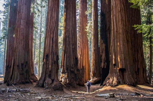
The sequoias that live on the western slopes of the Sierra Nevada in California are the largest trees in the world by volume. Erin Donalson/EyeEm via Getty Images

By Emily Lin, Head of Digital Curation and Scholarship, University of California, Merced.

Editor’s note: As wildfires came dangerously close to Sequoia and Kings Canyon National Parks in September 2020, the curator of the archives there worked with Emily Lin, librarian and head of digital curation at the University of California Merced, to evacuate the archives to keep them safe. In this interview, Lin explains how they evacuated the records, what’s in them and why they’re worth preserving.

Listen to Emily Lin of UC Merced talk about the archives and see the contents of the park archives and photos from the evacuation.

Why were the archives of Sequoia and King’s Canyon National Parks evacuated?

Ward Eldredge, the curator of the archives of the Sequoia and Kings Canyon National Parks, and I had been talking about the potential partnership around digitization of collections that had been housed there for a couple of years now. There’s been a concern about the safety of these records because wildfires in the past few years have been an annual threat. So the long-term safekeeping of the records was very much on Eldredge’s mind. And he pointed out that the UC Merced campus is located in one of the few areas in California that are outside of a high-risk fire zone and also outside of the risk of earthquakes. There was just no question that we would do whatever we could to bring them here for safekeeping.
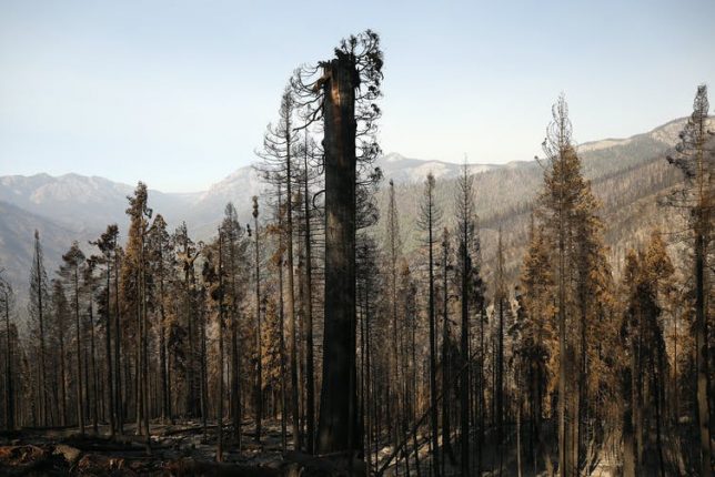
Alder Creek grove
The Castle Fire in October 2020 burned hundreds of Sequoias in the privately owned Alder Creek grove that NGO Save the Redwoods League purchased less than a year ago. Al Seib/LA Times via Getty Images

In September, when the fires got really close to the park, Eldredge was trying really hard to find a way to move the materials. He just couldn’t find a van or a truck because the residents in the area were also being called to evacuate, and there was a shortage. So in the course of a day, we managed to make arrangements to take our moving truck from campus, and he was able to secure a U-Haul truck. We were able to pack everything and move it out of the mountains to the UC Merced campus, which is two and a half hours away.

What’s in these archives?

There were hundreds of boxes of collections, about 600 linear feet, and also cabinets of plant specimens and artifacts.

It’s a complete record of the administrative history of the park. Sequoia was the second-oldest national park in the U.S., established in 1890. So there are records related to its founding and through to the 20th century. In letters written by the park directors to the U.S. president and the secretaries of the Department of the Interior, one can see how the thinking around managing public lands, conservation, fire and forest management changed over the last century.

Before the park was established, people would cut the sequoias down for timber. The city of Los Angeles wanted to build a dam in Kings Canyon up until 1965. So you can see how the thinking changed and how we got from that way of thinking to really establishing the National Park Service and protecting these unique environments.
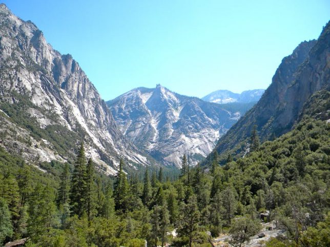
Kings Canyon
Kings Canyon is a rugged glacier-carved valley more than a mile deep. Crd637 via Wikimedia Commons, CC BY-SA

There’s an incredible photographic record – tens of thousands of photographs that cover pretty much every place within the park. There are maps of the sequoia groves, maps related to how trails and roads and other buildings were constructed. We take these trails for granted, but they were huge undertakings involving hundreds of workers breaking rocks, cutting trees and excavating for years. They worked through the winter sometimes to do it within schedule. These projects also provided jobs during the Great Depression.

Who will find them useful?

Anyone, from those within the parks who want to better understand the history of the park, to the rangers and the interpreters who want to provide and present that history to the general public. Ken Burns, the acclaimed documentary filmmaker, accessed these records while he was making his television series about the national parks.

They’ll also be more widely available for students to use. There’s plenty of material in there for lots of Ph.D. students working on dissertations and for those who want to really investigate how best to manage public lands and determine what’s effective. That knowledge is going to benefit the broader public and help conserve these national parks for all of us. There’s a rich record that can help us understand what is unique about the environment that allows these trees to survive.

What are the plans for keeping the archives at UC Merced?

When the records were kept in the park, it was just one person, Ward Eldredge, maintaining the records. That’s a lot of work. You could make an appointment and he could provide access if you wanted to come to the park, but it’s in a very small space within the park headquarters, so the accessibility was definitely limited. Now that these collections are at the library at UC Merced, it will be easier for people to be able to access them.

Our vision is to be able to digitize much of this material. Once it’s online, it will be a lot easier for people to at least see and maybe answer some of their immediate questions. And if there’s a need for them to see the physical material, they can still make arrangements to do that.

There’s still a long way to go, because normally, we would have to make a plan with the National Park Service, raise funds, build the facilities to store them safely and so on. Because we had to evacuate them, we still have to work on formalizing an agreement, but our goal is eventually to make sure that these records will be safe.


This article is republished from The Conversation under a Creative Commons license. Read the original article.

Climate Heat Melts Arctic Snows and Dries Forests

Fires now blaze under Arctic snows, where once even the wettest rainforests burned. Climate change delivers unlikely outcomes.

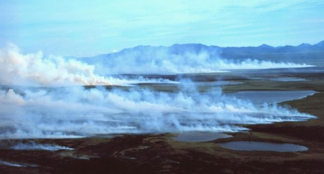
Boggy tundra in the western Arctic lets peat layers build up in the soil. Image: By Western Arctic National Parklands, via Wikimedia Commons

October 12, 2020 by Tim Radford, Climate News Network (CC BY-ND 4.0)

LONDON, 12 October, 2020 − The northern polar region isn’t just warming: it’s also smoking, as the rising heat thaws the Arctic snows. Researchers have identified a new class of fire hazard.

High above the Arctic Circle, fires that flared a year ago continued to smoulder under the snow through the winter to flare up again − two months earlier than usual, and on a scale not seen before.

And if the notion of fire and ice seems a surprise, prepare for the idea of a blazing rainforest. In a second and separate study, researchers exploring the climate lessons from the deep past 90 million years ago have found that, if the atmosphere is rich enough in oxygen, then even the wettest foliage can ignite and burn, to consume perhaps up to 40% of the world’s forest.

Scientists from the US report in Nature Geoscience that they have identified an unexpected threat from “zombie fires” which, despite heavy snowmelt, they say “can smoulder in carbon-rich peat below the surface for months or years, often only detectable through smoke released at the surface, and can even occur through cold winter months.”

The climate change we are causing now, it’s not something where if we don’t fix it, only our grandkids will have to deal with it. The impacts are really long-lasting”

—Garrett Boudinot, then at the University of Boulder Colorado and now with the Colorado Wildlife Council

They warn that in the fast-changing climate of the highest northern latitudes, the evidence from last year and this suggest that extreme temperatures and drier conditions mean there is a lot more surface fuel in the Arctic to catch fire and melt the Arctic snows.

Dwarf shrubs, sedges, mosses and grasses are invading the tundra, to join the surface peat, and even the bogs, fens and marches of the tundra are now burning. In all, 50% of the detected fires above 65° North − many in the Russian Arctic − happened on permafrost: that is, on ever-icy soils.

“It’s not just the amount of burned area that is alarming,” said Merritt Turetsky of the University of Colorado at Boulder, and one of the authors. “There are other trends we noticed in the satellite data that tell us how the Arctic fire regime is changing and what this spells for our climate future.”

Wildfires are on the increase now, in a world in which climate change has delivered hotter and drier conditions for many regions. Unexpectedly, according to a second study in Nature Geoscience, fossilized evidence in rocks in Utah has delivered evidence of massive and sustained forest fires, in the form of polycyclic aromatic hydrocarbons preserved in black shales laid down in the Cretaceous.

Huge absorption rate

Researchers pieced together a story of dramatic climate change 94 million years ago, when carbon dioxide built up in the atmosphere, and land and sea plants began to absorb it from the atmosphere on a massive scale. Microbial respiration stepped up too, and parts of the ocean became increasingly low in oxygen.

During 100,000 years of this, so much carbon had been buried in the ground or the oceans that – with the release of molecular oxygen, the O2 in CO2 − atmospheric oxygen levels began to increase. And with that, the scientists say, so did the probability of forest fires, even in wet forest ecosystems. Altogether, perhaps 30% to 40% of the planet’s forests were consumed by fire over 100 millennia.

“One of the consequences of having more oxygen in the atmosphere is that it’s easier to burn fires. It’s the same reason you blow on embers to stoke a fire,” said Garrett Boudinot, then at the University of Boulder Colorado and now with the Colorado Wildlife Council, who led the research.

“This finding highlights the prolonged impacts of climate change. The climate change we are causing now, it’s not something where if we don’t fix it, only our grandkids will have to deal with it. The history of climate change in Earth history tells us that the impacts are really long-lasting.” − Climate News Network

Western Wildfires Are Spinning Off Tornadoes – Here’s How Fires Create Their Own Freakish Weather

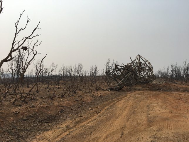
Fire tornado damage: WAPA's steel infrastructure mostly survived the fire intact, with one exception: the site of the fire tornado in Redding, July 26. The fire tornado destroyed at least three steel structures, including ripping two from the ground. Image by Western Area Power (Staff photo) (CC BY 2.0).
Fire tornado damage: WAPA’s steel infrastructure mostly survived the fire intact, with one exception: the site of the fire tornado in Redding, July 26. The fire tornado destroyed at least three steel structures, including ripping two from the ground. Image by Western Area Power (Staff photo) (CC BY 2.0).

By Charles Jones, Professor of Atmospheric Science, University of California, Santa Barbara and Leila Carvalho, Professor of Meteorology and Climatology, University of California, Santa Barbara. Published in collaboration with The Conversation (Public License).

It might sound like a bad movie, but extreme wildfires can create their own weather – including fire tornadoes.

It happened in California as a heat wave helped to fuel hundreds of wildfires across the region, many of them sparked by lightning. One fiery funnel cloud on Aug. 15 was so powerful, the National Weather Service issued what’s believed to be its first fire tornado warning.

So, what has to happen for a wildfire to get so extreme that it spins off tornadoes?

As professors who study wildfires and weather, we can offer some insights.

How Extreme Fire Conditions Form

Fires have three basic elements: heat, fuel and oxygen.

In a wildland fire, a heat source ignites the fire. Sometimes that ignition source is a car or power line or, as the West saw in mid-August, lightning strikes. Oxygen then reacts with dry vegetation to produce heat, ash and gases. How dry the landscape is determines whether the fire starts, how fast it burns and how hot the fire can get. It’s almost as important as wind.

Fire weather conditions get extreme when high temperatures, low humidity and strong winds combine with dead and live vegetation to produce difficult-to-fight, fast-spreading wildfires.

That combination is exactly what the West has been seeing. A wet winter fed the growth of grasses that now cover large areas of wildland in the western U.S. Most of this grass is now dead from the summer heat. Combined with other types of vegetation, that leaves lots of fuel for the wildfires to burn.

The remnants of Hurricane Elida also played a role. The storm increased moisture and instability in the atmosphere, which triggered thunderstorms further north. The atmosphere over land was pretty dry by then, and even when rain formed at the base of these clouds, it mostly evaporated due to the excessive heat. This led to “dry lightning” that ignited wildfires.

Wildfires Can Fuel Thunderstorms

Fires can also cause convection – hot air rises, and it moves water vapor, gases and aerosols upward.

Wildfires with turbulent plumes can produce a “cumulus” type of cloud, known as pyrocumulus or pyrocumulonimbus. Pyrocumulus clouds are similar to the cumulus clouds people are used to seeing. They develop when hot air carries moisture from plants, soil and air upward, where it cools and condenses. The centers of these “pyroclouds” have strong rising air.

It’s pretty common, and it’s a warning sign that firefighters could be facing erratic and dangerous conditions on the ground from the indraft of air toward the center of the blaze.

In some cases, the pyroclouds can reach 30,000 feet and produce lightning. There is evidence that pyrocumulus lightning may have ignited new blazes during the devastating fire storm in Australia in 2009 known as “Black Friday.”

Where do fire tornadoes come from?

Similar to the way cumulonimbus clouds produce tornadoes, these pyroclouds can produce fire‐generated vortices of ash, smoke and often flames that can get destructive.

A vortex can form because of the intense heat of the fire in an environment with strong winds. This is similar to a strong river flow passing through a depression. The sudden change in the speed of the flow will force the flow to rotate. Similarly, the heat generated by the fire creates a low pressure, and in an environment with strong winds, this process results in the formation of a vortex.

One fire tornado, or fire whirl, that developed during the deadly 2018 Carr Fire devastated parts of Redding, California, with winds clocked at over 143 miles per hour.

These vortices can also increase the severity of the fires themselves by sucking air rich in oxygen toward the center of the vortex. The hotter the fire, the higher the probability of stronger updrafts and stronger and larger vortices.

Persistent heat waves that dry out the land and vegetation have increased the potential of wildfires to be more violent and widespread.

Is extreme fire weather becoming more common?

Global warming has modified the Earth’s climate in ways that profoundly affect the behavior of wildfires.

Scientific evidence suggests that the severity of prolonged droughts and heat waves has been exacerbated not only by rising temperatures but also by changes in atmospheric circulation patterns associated with recent climate change. These changes can enhance extreme fire-weather behavior.

A study published Aug. 20 found that the frequency of California’s extreme fire weather days in the autumn fire season had more than doubled since the early 1980s. Over that four-decade period, autumn temperatures in the state rose by about 1.8 degrees Fahrenheit and autumn precipitation decreased by about 30%.

Firefighters and people living in wildfire-prone areas, meanwhile, need to be prepared for more extreme wildfires in the coming years.

The Conversation

This article is republished from The Conversation under a Creative Commons license. Read the original article.
Disclosure statement: Charles Jones receives funding from the National Science Foundation and the University of California. Leila Carvalho receives funding from the National Science Foundation.