How Curators Transferred Sequoia and King’s Canyon National Parks’ Archives to Escape Wildfires

sequoias
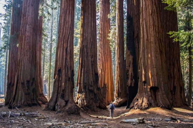
The sequoias that live on the western slopes of the Sierra Nevada in California are the largest trees in the world by volume. Erin Donalson/EyeEm via Getty Images

By Emily Lin, Head of Digital Curation and Scholarship, University of California, Merced.

Editor’s note: As wildfires came dangerously close to Sequoia and Kings Canyon National Parks in September 2020, the curator of the archives there worked with Emily Lin, librarian and head of digital curation at the University of California Merced, to evacuate the archives to keep them safe. In this interview, Lin explains how they evacuated the records, what’s in them and why they’re worth preserving.

Listen to Emily Lin of UC Merced talk about the archives and see the contents of the park archives and photos from the evacuation.

Why were the archives of Sequoia and King’s Canyon National Parks evacuated?

Ward Eldredge, the curator of the archives of the Sequoia and Kings Canyon National Parks, and I had been talking about the potential partnership around digitization of collections that had been housed there for a couple of years now. There’s been a concern about the safety of these records because wildfires in the past few years have been an annual threat. So the long-term safekeeping of the records was very much on Eldredge’s mind. And he pointed out that the UC Merced campus is located in one of the few areas in California that are outside of a high-risk fire zone and also outside of the risk of earthquakes. There was just no question that we would do whatever we could to bring them here for safekeeping.
Alder Creek grove
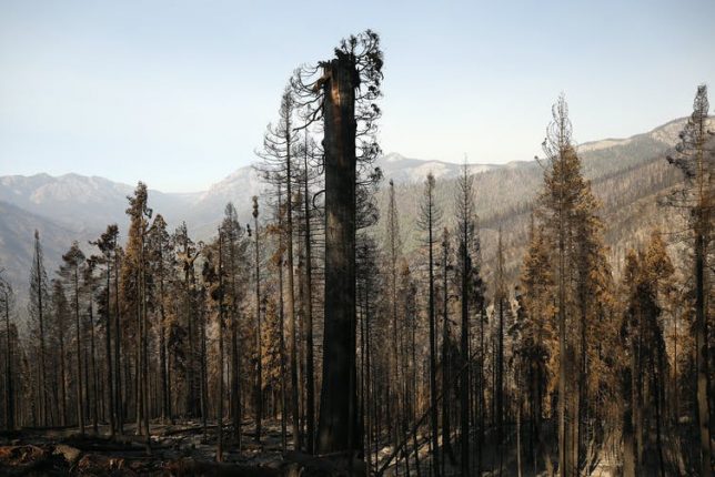
The Castle Fire in October 2020 burned hundreds of Sequoias in the privately owned Alder Creek grove that NGO Save the Redwoods League purchased less than a year ago. Al Seib/LA Times via Getty Images

In September, when the fires got really close to the park, Eldredge was trying really hard to find a way to move the materials. He just couldn’t find a van or a truck because the residents in the area were also being called to evacuate, and there was a shortage. So in the course of a day, we managed to make arrangements to take our moving truck from campus, and he was able to secure a U-Haul truck. We were able to pack everything and move it out of the mountains to the UC Merced campus, which is two and a half hours away.

What’s in these archives?

There were hundreds of boxes of collections, about 600 linear feet, and also cabinets of plant specimens and artifacts.

It’s a complete record of the administrative history of the park. Sequoia was the second-oldest national park in the U.S., established in 1890. So there are records related to its founding and through to the 20th century. In letters written by the park directors to the U.S. president and the secretaries of the Department of the Interior, one can see how the thinking around managing public lands, conservation, fire and forest management changed over the last century.

Before the park was established, people would cut the sequoias down for timber. The city of Los Angeles wanted to build a dam in Kings Canyon up until 1965. So you can see how the thinking changed and how we got from that way of thinking to really establishing the National Park Service and protecting these unique environments.
Kings Canyon
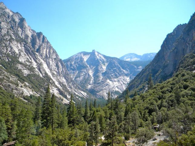
Kings Canyon is a rugged glacier-carved valley more than a mile deep. Crd637 via Wikimedia Commons, CC BY-SA

There’s an incredible photographic record – tens of thousands of photographs that cover pretty much every place within the park. There are maps of the sequoia groves, maps related to how trails and roads and other buildings were constructed. We take these trails for granted, but they were huge undertakings involving hundreds of workers breaking rocks, cutting trees and excavating for years. They worked through the winter sometimes to do it within schedule. These projects also provided jobs during the Great Depression.

Who will find them useful?

Anyone, from those within the parks who want to better understand the history of the park, to the rangers and the interpreters who want to provide and present that history to the general public. Ken Burns, the acclaimed documentary filmmaker, accessed these records while he was making his television series about the national parks.

They’ll also be more widely available for students to use. There’s plenty of material in there for lots of Ph.D. students working on dissertations and for those who want to really investigate how best to manage public lands and determine what’s effective. That knowledge is going to benefit the broader public and help conserve these national parks for all of us. There’s a rich record that can help us understand what is unique about the environment that allows these trees to survive.

What are the plans for keeping the archives at UC Merced?

When the records were kept in the park, it was just one person, Ward Eldredge, maintaining the records. That’s a lot of work. You could make an appointment and he could provide access if you wanted to come to the park, but it’s in a very small space within the park headquarters, so the accessibility was definitely limited. Now that these collections are at the library at UC Merced, it will be easier for people to be able to access them.

Our vision is to be able to digitize much of this material. Once it’s online, it will be a lot easier for people to at least see and maybe answer some of their immediate questions. And if there’s a need for them to see the physical material, they can still make arrangements to do that.

There’s still a long way to go, because normally, we would have to make a plan with the National Park Service, raise funds, build the facilities to store them safely and so on. Because we had to evacuate them, we still have to work on formalizing an agreement, but our goal is eventually to make sure that these records will be safe.


This article is republished from The Conversation under a Creative Commons license. Read the original article.

Returning the ‘Three Sisters’ – Corn, Beans, and Squash – to Native American Farms Nourishes People, Land, and Cultures

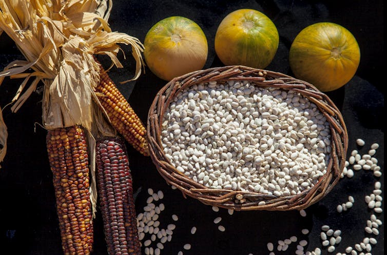
The ‘three sisters’ are staple foods for many Native American tribes. Marilyn Angel Wynn/Getty Images

By Christina Gish Hill, Associate Professor of Anthropology, Iowa State University.

Historians know that turkey and corn were part of the first Thanksgiving, when Wampanoag peoples shared a harvest meal with the pilgrims of Plymouth plantation in Massachusetts. And traditional Native American farming practices tell us that squash and beans likely were part of that 1621 dinner too.

For centuries before Europeans reached North America, many Native Americans grew these foods together in one plot, along with the less familiar sunflower. They called the plants sisters to reflect how they thrived when they were cultivated together.

Today three-quarters of Native Americans live off of reservations, mainly in urban areas. And nationwide, many Native American communities lack access to healthy food. As a scholar of Indigenous studies focusing on Native relationships with the land, I began to wonder why Native farming practices had declined and what benefits could emerge from bringing them back.

To answer these questions, I am working with agronomist Marshall McDaniel, horticulturalist Ajay Nair, nutritionist Donna Winham and Native gardening projects in Iowa, Nebraska, Wisconsin and Minnesota. Our research project, “Reuniting the Three Sisters,” explores what it means to be a responsible caretaker of the land from the perspective of peoples who have been balancing agricultural production with sustainability for hundreds of years.

Abundant harvests

Historically, Native people throughout the Americas bred indigenous plant varieties specific to the growing conditions of their homelands. They selected seeds for many different traits, such as flavor, texture and color.

Native growers knew that planting corn, beans, squash and sunflowers together produced mutual benefits. Corn stalks created a trellis for beans to climb, and beans’ twining vines secured the corn in high winds. They also certainly observed that corn and bean plants growing together tended to be healthier than when raised separately. Today we know the reason: Bacteria living on bean plant roots pull nitrogen – an essential plant nutrient – from the air and convert it to a form that both beans and corn can use.

Squash plants contributed by shading the ground with their broad leaves, preventing weeds from growing and retaining water in the soil. Heritage squash varieties also had spines that discouraged deer and raccoons from visiting the garden for a snack. And sunflowers planted around the edges of the garden created a natural fence, protecting other plants from wind and animals and attracting pollinators.

Interplanting these agricultural sisters produced bountiful harvests that sustained large Native communities and spurred fruitful trade economies. The first Europeans who reached the Americas were shocked at the abundant food crops they found. My research is exploring how, 200 years ago, Native American agriculturalists around the Great Lakes and along the Missouri and Red rivers fed fur traders with their diverse vegetable products.

Displaced from the land

As Euro-Americans settled permanently on the most fertile North American lands and acquired seeds that Native growers had carefully bred, they imposed policies that made Native farming practices impossible. In 1830 President Andrew Jackson signed the Indian Removal Act, which made it official U.S. policy to force Native peoples from their home locations, pushing them onto subpar lands.

On reservations, U.S. government officials discouraged Native women from cultivating anything larger than small garden plots and pressured Native men to practice Euro-American style monoculture. Allotment policies assigned small plots to nuclear families, further limiting Native Americans’ access to land and preventing them from using communal farming practices.

Native children were forced to attend boarding schools, where they had no opportunity to learn Native agriculture techniques or preservation and preparation of Indigenous foods. Instead they were forced to eat Western foods, turning their palates away from their traditional preferences. Taken together, these policies almost entirely eradicated three sisters agriculture from Native communities in the Midwest by the 1930s.

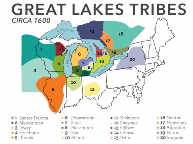
Native American tribes in the Great Lakes region pre-European settlement. Milwaukee Public Museum, CC BY-ND

Reviving Native agriculture

Today Native people all over the U.S. are working diligently to reclaim Indigenous varieties of corn, beans, squash, sunflowers and other crops. This effort is important for many reasons.

Improving Native people’s access to healthy, culturally appropriate foods will help lower rates of diabetes and obesity, which affect Native Americans at disproportionately high rates. Sharing traditional knowledge about agriculture is a way for elders to pass cultural information along to younger generations. Indigenous growing techniques also protect the lands that Native nations now inhabit, and can potentially benefit the wider ecosystems around them.

But Native communities often lack access to resources such as farming equipment, soil testing, fertilizer and pest prevention techniques. This is what inspired Iowa State University’s Three Sisters Gardening Project. We work collaboratively with Native farmers at Tsyunhehkw, a community agriculture program, and the Ohelaku Corn Growers Co-Op on the Oneida reservation in Wisconsin; the Nebraska Indian College, which serves the Omaha and Santee Sioux in Nebraska; and Dream of Wild Health, a nonprofit organization that works to reconnect the Native American community in Minneapolis-St. Paul, Minnesota, with traditional Native plants and their culinary, medicinal and spiritual uses.

We are growing three sisters research plots at ISU’s Horticulture Farm and in each of these communities. Our project also runs workshops on topics of interests to Native gardeners, encourages local soil health testing and grows rare seeds to rematriate them, or return them to their home communities.

The monocropping industrial agricultural systems that produce much of the U.S. food supply harms the environment, rural communities and human health and safety in many ways. By growing corn, beans and squash in research plots, we are helping to quantify how intercropping benefits both plants and soil.

By documenting limited nutritional offerings at reservation grocery stores, we are demonstrating the need for Indigenous gardens in Native communities. By interviewing Native growers and elders knowledgeable about foodways, we are illuminating how healing Indigenous gardening practices can be for Native communities and people – their bodies, minds and spirits.

Our Native collaborators are benefiting from the project through rematriation of rare seeds grown in ISU plots, workshops on topics they select and the new relationships they are building with Native gardeners across the Midwest. As researchers, we are learning about what it means to work collaboratively and to conduct research that respects protocols our Native collaborators value, such as treating seeds, plants and soil in a culturally appropriate manner. By listening with humility, we are working to build a network where we can all learn from one another.

This article is republished from The Conversation under a Creative Commons license. Read the original article.
Preserving Cultural and Historic Treasures in a Changing Climate May Mean Transforming Them

Photo by Federico Beccari on Unsplash

By Erin Seekamp, Professor of Parks, Recreation and Tourism Management, North Carolina State University

With global travel curtailed during the COVID-19 pandemic, many people are finding comfort in planning future trips. But imagine that you finally arrive in Venice and the “floating city” is flooded. Would you stay anyway, walking through St. Mark’s Square on makeshift catwalks or elevated wooden passages – even if you couldn’t enter the Basilica or the Doge’s Palace? Or would you leave and hope to visit sometime in the future?

The United Nations Intergovernmental Panel on Climate Change recently reported that over the next 30 years flooding in Venice will increase. With the Adriatic Sea rising a few millimeters each year, severe flooding that once happened every 100 years is predicted to happen every six years by 2050, and every five months by 2100.

Venice is just one example of the challenges of preserving iconic landmarks that are threatened by the effects of climate change, such as rising seas and recurrent, intensifying droughts, storms and wildfires. In my research as a social scientist, I help heritage managers make tough decisions prioritizing which sites to save when funds, time or both are limited.

That includes planning for threatened World Heritage sites designated as cultural or natural treasures by the United Nations Educational, Scientific and Cultural Organization. Many U.S. national parks are also at risk. And as I see it, success will require new thinking about what preservation means.

Cultural heritage sites threatened by climate change include cities, towns and national parks.

Ways of adapting

Across the globe, innumerable cultural sites face storm-related flooding, erosion and inundation from rising seas. They include many in the U.S., such as Jamestown Island in Virginia, New York’s Statue of Liberty and Charleston, South Carolina’s Historic District.

Experts in cultural preservation worldwide agree that it is impossible to protect all of these places forever. Many would require constant restoration. Others will need defenses like sea walls and flood gates – but those defenses might not be effective for long.

Some sites could be protected in ways that visibly alter them – for example, elevating or moving buildings, or allowing them to be damaged or removed from the landscape. Such steps go beyond restoration, which can conflict with mandates to preserve sites and structures in perpetuity.

Damage from Hurricane Sandy in 2012 shut down New York’s Statue of Liberty and the Ellis Island immigration museum for months.

Saving historic North Carolina buildings

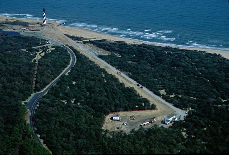
An early test of this approach occurred in 1999, when relentless erosion of the North Carolina shoreline forced the National Park Service to move the Cape Hatteras Lighthouse and Keeper’s Quarters about a half-mile inland. Relocating these mid-19th-century structures cost $US11.8 million and sparked debate about how to deal with other imperiled historic buildings.

In 2015, managers at North Carolina’s Cape Lookout National Seashore realized that buildings in Portsmouth Village and Cape Lookout Village, two maritime historic districts on barrier islands, were endangered by storm-related flooding and rising seas. Portsmouth Village, which dates to 1753, served as a thriving port town during colonial settlement, while Cape Lookout Village provided navigational support with construction of a lighthouse in 1812 that was replaced in 1859.

These buildings are listed on the National Register of Historic Places, which requires managers to preserve them in perpetuity. But officials were uncertain about which historic buildings to save first. They also had to identify a strategy, such as moving or even removing buildings, that would maximize the significance preserved across the park’s landscape.

I developed a process to quantify the relative significance of historic buildings to help them. Our team then created a planning tool to help National Park Service managers make cost-effective decisions. Our model compiles data on each building’s significance and vulnerability. It evaluates adaptation costs, such as elevating or relocating buildings, given available funding, and charts possible strategies over a 30-year period.

Photo of Cape Hatters Light and path to new site.
In 1999 the National Park Service moved the historic Cape Hatteras Lighthouse 2,900 feet inland (new site at lower right in photo) to protect it from shoreline erosion. Mike Booher/NPS

When we tested the model on 17 flood-prone Cape Lookout buildings, we found that the best strategies were elevating them in place or moving them to higher ground and then elevating them. However, interviews with local people revealed that changing the location or the look of these buildings upset some former residents and their descendants.

Many people we talked to held deep connections to these places that were part of their personal, family and community identities. Surprisingly, some said they would rather lose some of these buildings than alter them. Other stakeholders – including members of partner organizations and park visitors – had different opinions on what should be done.

After Hurricane Dorian severely damaged Portsmouth Village in 2019, park managers made the hard decision to dismantle and remove some of the buildings while restoring others. But an important question remains: What should be done at other highly vulnerable locations?

Climate-challenged World Heritage sites

These findings inspired me to explore global, people-centered approaches to preservation and the international policies governing them.

Climate change threatens many World Heritage sites. Some are archaeological sites, like Peru’s Chan Chan, the largest adobe city on Earth, and the ancestral Pueblo cliff dwellings in Colorado’s Mesa Verde National Park. Entire cities – including Venice – and historic buildings such as Australia’s Sydney Opera House are also in harm’s way.

Current policy recommendations focus on restoration or defenses, and oppose physical change. In fact, the only process that exists is to add sites undergoing physical change to the List of World Heritage Sites in Danger. However, adding a site to the “danger” list is politically undesirable because it can generate bad press, reduce tourism revenue and deter funders from supporting rescue efforts.

The need to transform

My research calls for a more proactive approach, including preemptive efforts to prevent damage. I see a need for a new category: “World Heritage Sites in Climatic Transformation.”

This approach draws on the ecological concept of resilience, which is essentially the ability to survive by changing and adapting. It would allow managers to repair, adapt or even transform vulnerable places. This new classification would place communities at the center of the planning process and create a searchable database of climate impacts and interventions.

Transforming heritage sites may be controversial, but the clock is ticking. Researching, designing and constructing defenses takes time. For example, floodgates installed to protect Venice are being tested a decade later than planned.

In my view, saving cultural and historic sites from climate change will require a new approach to heritage preservation that includes transformation. Now is the time to think creatively, with input from people whose heritages are represented in these places, to discover new pathways to protecting them.

This article is republished from The Conversation under a Creative Commons license. Read the original article.